Climate for Station: Giles Meteorological Office, Western Australia, Australia
Loading live weather...
Climate Analysis & Overview
Giles Meteorological Office, located in Warakurna, Western Australia, is experiencing a warming trend, particularly in low temperatures, over the past decade. The region's precipitation is becoming slightly more evenly distributed, contributing to a nuanced climate profile for this arid zone.
Desert Climate Dynamics
Giles Meteorological Office is situated in a region classified under the Köppen climate classification as BWh, indicative of a hot desert climate. The arid landscape, characterised by sparse vegetation and minimal water bodies, influences the temperature and precipitation patterns observed here. Over the past decade, the station has recorded a notable warming trend in low temperatures, with an increase of 0.59°C (1.06°F). This is more pronounced than the all-time trend for lows, which shows a rise of 0.10°C (0.17°F). High temperatures have also increased by 0.25°C (0.45°F) over the last ten years, compared to an all-time rise of 0.21°C (0.38°F). These figures suggest an acceleration in warming, particularly affecting nighttime temperatures.
Temperature Extremes and Records
The station has recorded some extreme temperatures, with a maximum of 46.8°C (116.2°F) and a minimum of -2.5°C (27.5°F). These records underscore the broad thermal range experienced in this desert region, reflecting both the intense heat of the day and the potential for significant cooling at night. Such extremes are typical of desert climates, where the absence of moisture in the air leads to rapid temperature fluctuations.
Precipitation Patterns and Changes
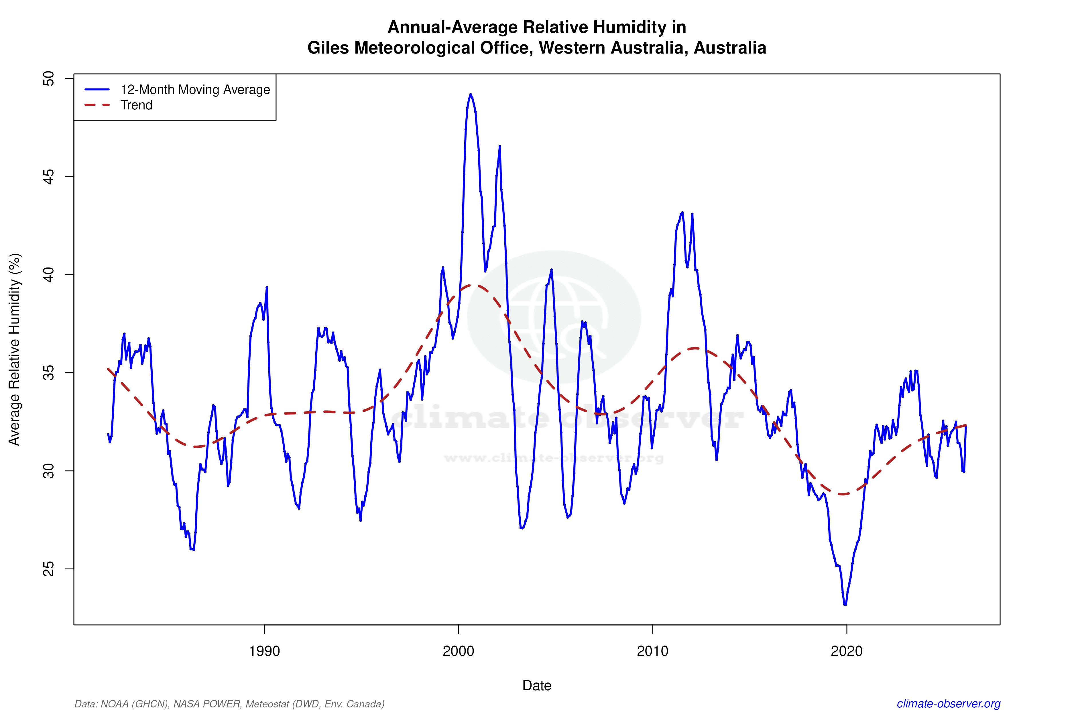
The Precipitation Concentration Index (PCI) at Giles has seen a slight decrease from a baseline of 24.7 to a current value of 22.6. This suggests that precipitation events are becoming marginally more evenly distributed throughout the year, although they remain highly concentrated. In a region where water is a precious resource, even slight shifts in precipitation patterns can have significant ecological and hydrological implications.
Regional Climate Context
In the broader context of Australia's climate goals, which include reducing greenhouse gas emissions and adapting to climate change impacts, the trends observed at Giles are particularly relevant. The warming trends, especially in minimum temperatures, align with national patterns of increased temperatures. The slight shift towards more evenly distributed precipitation could offer some resilience against drought conditions, though the overall arid nature of the region remains a challenge.
Implications for the Future
The data from Giles Meteorological Office provides critical insights into the ongoing climatic shifts in Australia's desert regions. As the country continues to grapple with the impacts of climate change, understanding these localised trends is essential for developing effective adaptation strategies. The warming of minimum temperatures and changes in precipitation distribution are key factors that will influence future climate resilience efforts in this part of Western Australia.
Station Statistics
10-Year Trend
High: +0.20 °C/decade
Low: +0.81 °C/decade
Rain: -0.08 mm/decade
25-Year Trend
High: +0.63 °C/decade
Low: +0.23 °C/decade
Rain: -0.11 mm/decade
50-Year Trend
High: +0.26 °C/decade
Low: +0.12 °C/decade
Rain: +0.01 mm/decade
All-Time Trend
High: +0.21 °C/decade
Low: +0.10 °C/decade
Rain: -0.00 mm/decade
Percentage Above-Average Days
Last 12 Months: 58.6%
This Year: 60.3%
Precipitation Concentration Index (PCI) ℹ️
Last 12 Months: 21.9
Historical Average: 22.6
Percentile Rank of Last 12 Months ℹ️
High: 92nd percentile
Low: 90th percentile
Rain: 41st percentile
Change in Variance ℹ️
High: -1.5%
Low: +7.2%
Intraday: +4.8%
Data Coverage
99.3%
First Year of Data
1956
Station Location
Historical Weather Records
| Max High | Avg High | Min High | Max Avg | Avg Avg | Min Avg | Max Low | Avg Low | Min Low | Max Precipitation | Avg Precipitation | Max Snow | Avg Snow | |
|---|---|---|---|---|---|---|---|---|---|---|---|---|---|
| Record | 46.8 °C | — | 9.0 °C | 39.2 °C | — | 5.9 °C | 32.5 °C | — | -2.5 °C | 217.2 mm | — | — | — |
| January | 45.7 °C | 37.4 °C | 21.6 °C | 39.2 °C | 30.7 °C | 15.6 °C | 32.0 °C | 23.6 °C | 11.7 °C | 37.6 mm | 0.9 mm | — | — |
| February | 44.4 °C | 36.2 °C | 19.2 °C | 37.6 °C | 29.6 °C | 16.2 °C | 32.5 °C | 22.9 °C | 9.8 °C | 217.2 mm | 1.4 mm | — | — |
| March | 44.6 °C | 34.1 °C | 15.1 °C | 36.3 °C | 27.5 °C | 14.2 °C | 30.7 °C | 20.8 °C | 8.9 °C | 90.2 mm | 0.8 mm | — | — |
| April | 38.9 °C | 29.6 °C | 14.2 °C | 32.3 °C | 23.2 °C | 10.9 °C | 27.4 °C | 16.5 °C | 5.4 °C | 54.2 mm | 0.4 mm | — | — |
| May | 33.9 °C | 23.8 °C | 10.6 °C | 27.7 °C | 17.7 °C | 7.7 °C | 23.3 °C | 11.2 °C | 1.8 °C | 34.9 mm | 0.5 mm | — | — |
| June | 29.9 °C | 20.4 °C | 12.1 °C | 23.6 °C | 14.3 °C | 5.9 °C | 20.2 °C | 8.0 °C | -1.6 °C | 42.2 mm | 0.5 mm | — | — |
| July | 30.8 °C | 20.3 °C | 9.2 °C | 24.5 °C | 13.8 °C | 6.1 °C | 20.5 °C | 6.8 °C | -2.5 °C | 32.5 mm | 0.2 mm | — | — |
| August | 36.1 °C | 23.0 °C | 9.0 °C | 27.9 °C | 16.3 °C | 5.9 °C | 20.8 °C | 8.8 °C | -1.4 °C | 43.2 mm | 0.2 mm | — | — |
| September | 38.2 °C | 27.8 °C | 11.4 °C | 31.6 °C | 20.9 °C | 8.5 °C | 25.5 °C | 13.0 °C | 2.0 °C | 37.4 mm | 0.2 mm | — | — |
| October | 41.6 °C | 32.1 °C | 15.4 °C | 34.7 °C | 25.1 °C | 10.3 °C | 29.3 °C | 17.3 °C | 4.2 °C | 39.4 mm | 0.4 mm | — | — |
| November | 43.9 °C | 34.5 °C | 17.8 °C | 36.9 °C | 27.4 °C | 13.7 °C | 30.0 °C | 19.9 °C | 7.0 °C | 51.6 mm | 0.8 mm | — | — |
| December | 46.8 °C | 36.1 °C | 16.7 °C | 39.1 °C | 29.2 °C | 13.3 °C | 32.1 °C | 22.0 °C | 9.5 °C | 60.7 mm | 1.3 mm | — | — |
Data Visualisations
Remove WatermarksCurrent Year Climate Trends vs Historical


Max Temperature this Year | 1 of 6
Climate 12-Month Moving Averages

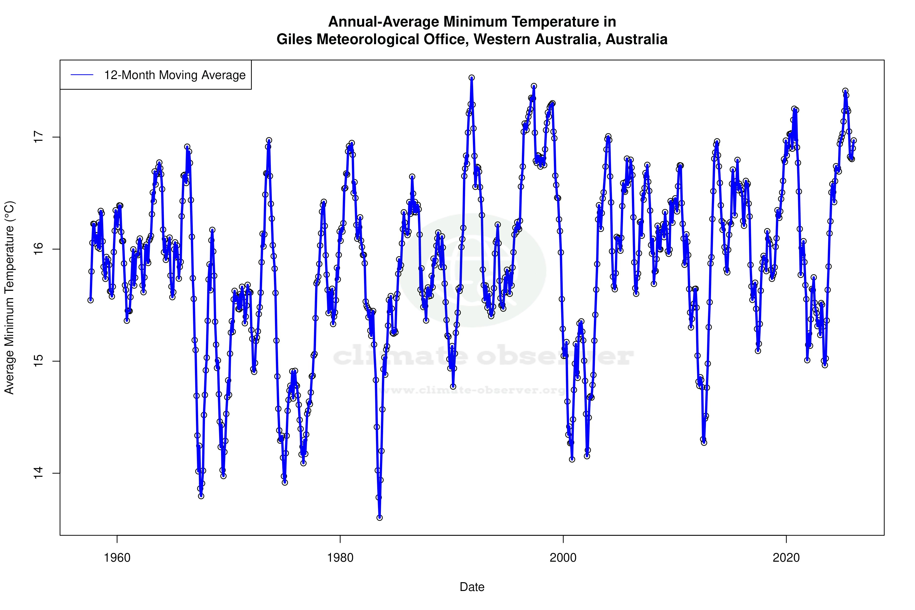


Max Temperature 12-Month MA | 1 of 6
Daily Data Points and Averages Throughout the Year


Average Max Temperature Throughout Year | 1 of 5