Climate for Station: Qui Nhon, Binh Dinh, Vietnam
Loading live weather...
Climate Analysis & Overview
Qui Nhon is experiencing a complex climatic evolution, with a notable divergence between short-term and long-term temperature trends. While recent years show a significant warming of 2.57°C (4.63°F) in high temperatures, the all-time data reveals a more modest warming of 0.05°C (0.09°F). Precipitation is becoming more evenly distributed, as indicated by a decrease in the Precipitation Concentration Index (PCI).
Coastal Climate Dynamics
Qui Nhon, located at the coordinates 13.7667°N, 109.2167°E, is characterised by a tropical savanna climate under the Köppen classification. The city's coastal position along the South China Sea influences its weather patterns, contributing to the warm temperatures and seasonal monsoon rains typical of the region. The surrounding geography, including nearby mountains, can modulate these effects, leading to microclimatic variations.
Short-Term Warming Trends
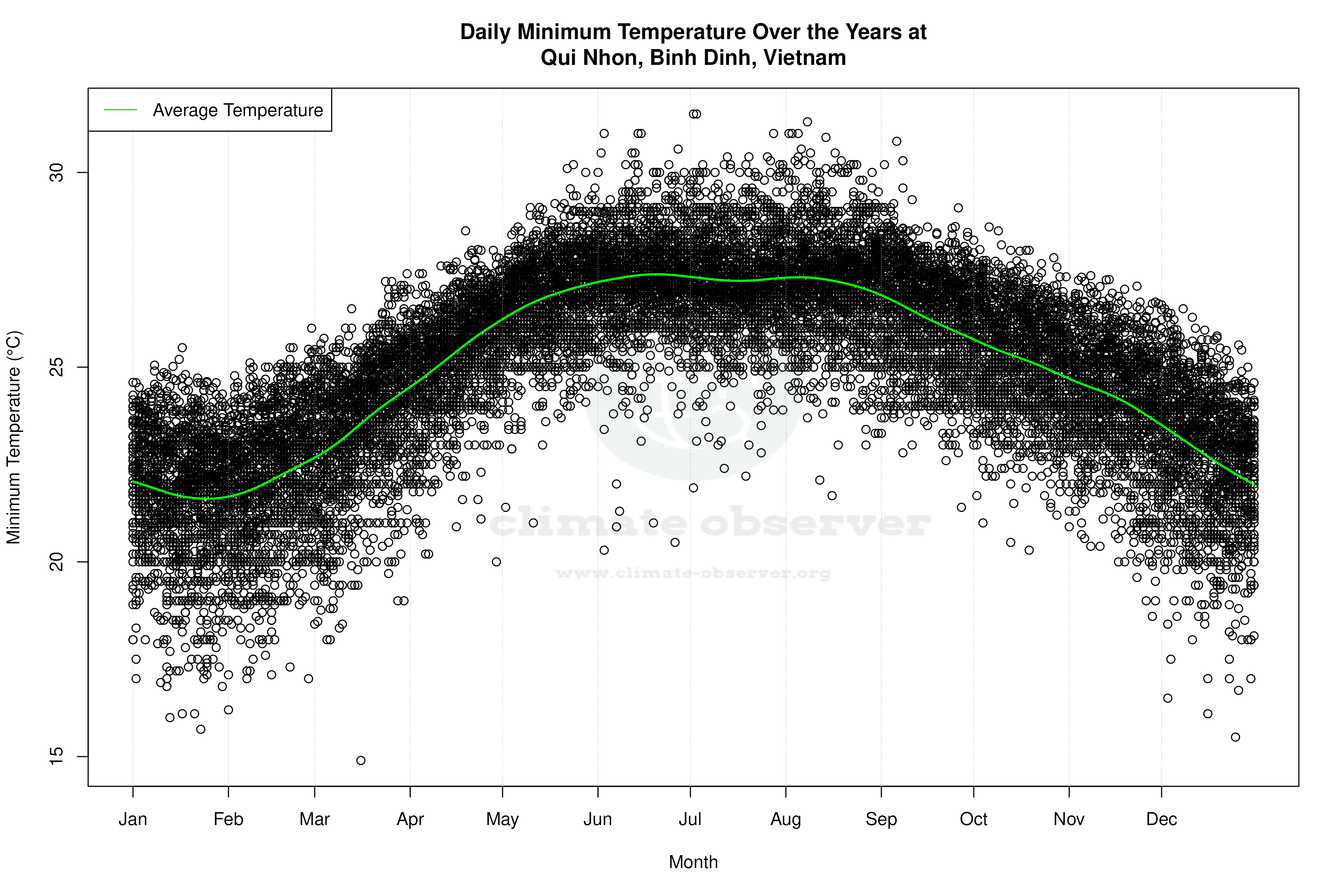
Over the past decade, Qui Nhon has experienced a significant warming trend in high temperatures, with an increase of 2.57°C (4.63°F). This trend contrasts with a cooling in low temperatures by 1.17°C (2.10°F). Such a disparity suggests an increase in temperature variability, potentially linked to regional climate shifts or urban heat effects. This warming trend is critical for local agriculture and energy consumption, impacting both crop viability and cooling demands.
Long-Term Temperature Stability
In contrast to the recent warming, the long-term data presents a more stable temperature profile. High temperatures have risen by only 0.05°C (0.09°F), while low temperatures have seen a slight increase of 0.10°C (0.18°F). This suggests that while short-term fluctuations are pronounced, the overall climate has remained relatively stable over a more extended period. This stability is crucial for long-term planning in sectors such as infrastructure and water management.
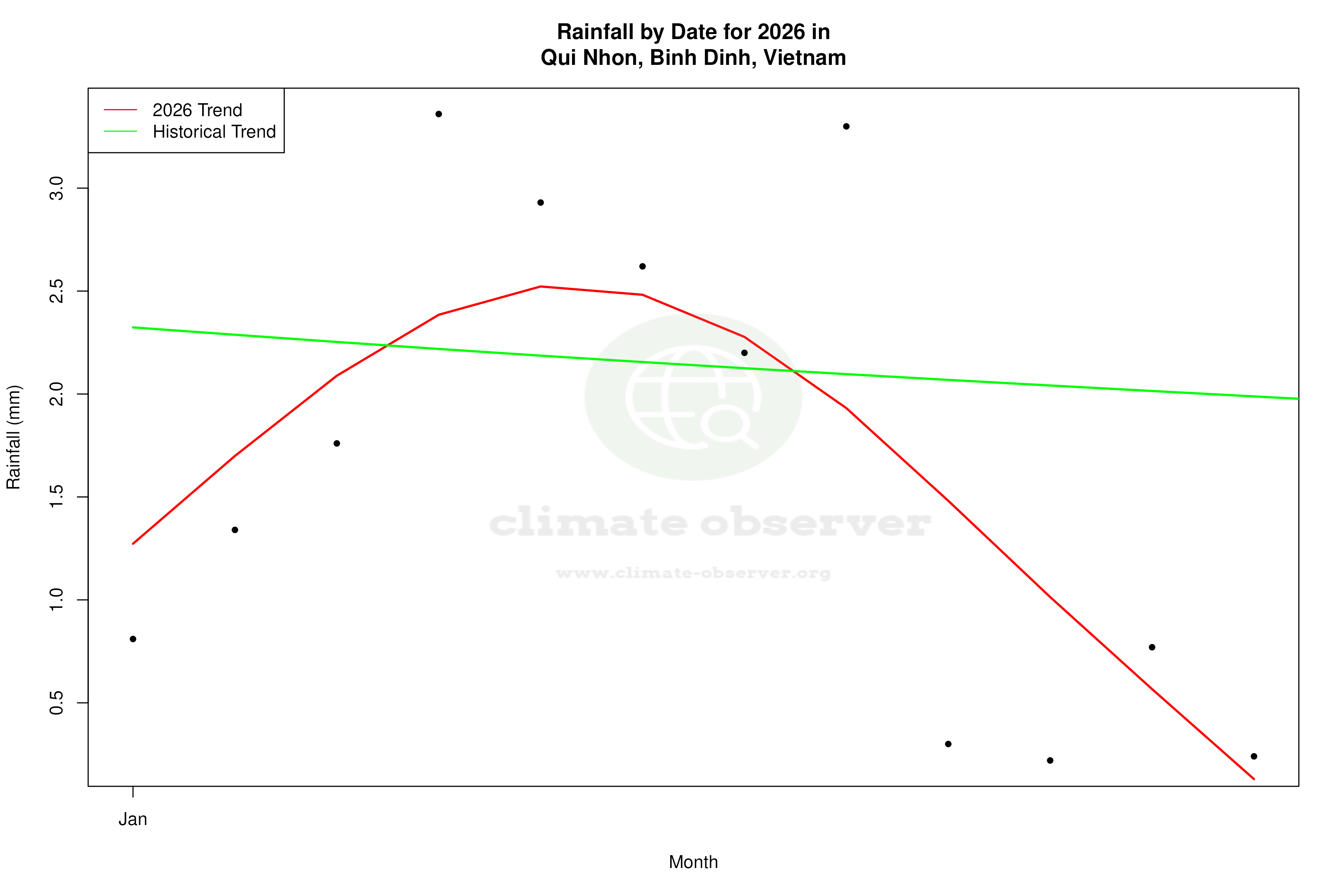
Precipitation Patterns and Distribution
The Precipitation Concentration Index (PCI) provides insights into the distribution of rainfall events. Qui Nhon's PCI has decreased from a baseline of 18.57 to a current value of 14.15, indicating a more even distribution of precipitation throughout the year. This change can mitigate the risks of flooding and drought, providing a more reliable water supply for agriculture and urban needs.
Regional Implications and Future Considerations
These climatic trends occur against the backdrop of Vietnam's broader regional climate goals, which focus on mitigating the impacts of climate change through sustainable development and resilience building. Recent weather events, such as typhoons and heavy monsoon rains, underscore the importance of understanding and adapting to these evolving climatic patterns. As Qui Nhon navigates these changes, the integration of climate data into policy and planning will be essential for sustainable development.
Station Statistics
10-Year Trend
High: +4.23 °F/decade
Low: -2.36 °F/decade
Rain: -0.078 in/decade
25-Year Trend
High: -0.99 °F/decade
Low: -0.07 °F/decade
Rain: +0.022 in/decade
50-Year Trend
High: +0.08 °F/decade
Low: +0.06 °F/decade
Rain: +0.031 in/decade
All-Time Trend
High: +0.08 °F/decade
Low: +0.16 °F/decade
Rain: +0.025 in/decade
Percentage Above-Average Days
Last 12 Months: 40.6%
This Year: 14.8%
Precipitation Concentration Index (PCI) ℹ️
Last 12 Months: 18.9
Historical Average: 20.6
Percentile Rank of Last 12 Months ℹ️
High: 38th percentile
Low: 4th percentile
Rain: 68th percentile
Change in Variance ℹ️
High: -12.2%
Low: +15.6%
Intraday: -12.5%
Data Coverage
80.7%
First Year of Data
1957
Station Location
Historical Weather Records
| Max High | Avg High | Min High | Max Avg | Avg Avg | Min Avg | Max Low | Avg Low | Min Low | Max Precipitation | Avg Precipitation | Max Snow | Avg Snow | |
|---|---|---|---|---|---|---|---|---|---|---|---|---|---|
| Record | 105.26 °F | — | 66.92 °F | 96.08 °F | — | 64.04 °F | 88.70 °F | — | 59.90 °F | 12.75 in | — | 0.00 in | — |
| January | 91.94 °F | 79.06 °F | 66.92 °F | 83.30 °F | 74.36 °F | 64.04 °F | 77.90 °F | 71.09 °F | 60.26 °F | 2.80 in | 0.07 in | 0.00 in | 0.00 in |
| February | 95.00 °F | 80.91 °F | 69.80 °F | 82.58 °F | 75.54 °F | 65.66 °F | 78.80 °F | 71.82 °F | 61.16 °F | 0.99 in | 0.03 in | 0.00 in | 0.00 in |
| March | 100.04 °F | 83.82 °F | 68.09 °F | 87.26 °F | 78.39 °F | 67.01 °F | 81.32 °F | 74.37 °F | 64.40 °F | 4.05 in | 0.03 in | 0.00 in | 0.00 in |
| April | 102.74 °F | 87.26 °F | 75.20 °F | 92.12 °F | 81.69 °F | 71.42 °F | 83.30 °F | 77.61 °F | 68.00 °F | 2.47 in | 0.04 in | 0.00 in | 0.00 in |
| May | 105.26 °F | 90.49 °F | 77.90 °F | 93.38 °F | 84.52 °F | 75.92 °F | 86.36 °F | 80.24 °F | 69.80 °F | 3.54 in | 0.11 in | 0.00 in | 0.00 in |
| June | 104.00 °F | 92.19 °F | 78.62 °F | 93.56 °F | 86.08 °F | 75.02 °F | 87.80 °F | 81.22 °F | 69.62 °F | 6.00 in | 0.08 in | 0.00 in | 0.00 in |
| July | 103.10 °F | 92.43 °F | 80.92 °F | 93.92 °F | 85.93 °F | 76.10 °F | 88.70 °F | 81.05 °F | 71.42 °F | 2.00 in | 0.06 in | 0.00 in | 0.00 in |
| August | 102.20 °F | 92.62 °F | 79.70 °F | 96.08 °F | 85.89 °F | 77.36 °F | 88.34 °F | 80.93 °F | 71.06 °F | 2.92 in | 0.11 in | 0.00 in | 0.00 in |
| September | 103.10 °F | 89.48 °F | 78.44 °F | 93.74 °F | 83.65 °F | 74.84 °F | 87.44 °F | 79.33 °F | 70.52 °F | 7.83 in | 0.30 in | 0.00 in | 0.00 in |
| October | 98.60 °F | 85.51 °F | 74.66 °F | 87.62 °F | 80.57 °F | 70.70 °F | 83.48 °F | 77.41 °F | 68.54 °F | 12.75 in | 0.56 in | 0.00 in | 0.00 in |
| November | 102.20 °F | 82.35 °F | 71.60 °F | 84.38 °F | 78.19 °F | 68.18 °F | 81.23 °F | 75.54 °F | 65.48 °F | 10.11 in | 0.52 in | 0.00 in | 0.00 in |
| December | 93.92 °F | 79.41 °F | 67.10 °F | 83.12 °F | 75.34 °F | 64.22 °F | 79.88 °F | 72.85 °F | 59.90 °F | 6.02 in | 0.23 in | 0.00 in | 0.00 in |
Data Visualisations
Remove WatermarksCurrent Year Climate Trends vs Historical


Max Temperature this Year | 1 of 6
Climate 12-Month Moving Averages


Max Temperature 12-Month MA | 1 of 6
Daily Data Points and Averages Throughout the Year


Average Max Temperature Throughout Year | 1 of 5
